
The Appalachian Trail - Here Today but Gone Tomorrow
The Early Days before Bent Tree – Part 5
By: Don & Diane Wells
In 1921 Benton MacKaye proposed the building of a hiking trail that would reach from Georgia to Maine. The trail along the Appalachian Mountains was to be a “Wilderness experience.” Appalachian Trail Clubs under the Appalachian Trail Conference were formed to manage the planning and building of the trail through each state. Deciding just where the trail should go was difficult, especially in Georgia. Connecting the trail route from Georgia to North Carolina or Tennessee was as major issue. The book, Friendships of the Trail, The History of the Georgia Appalachian Trail Club 1930-1980 provides an interesting account of many of the meetings held between the planners in the early days as they tried to determine the location of the trail. The Great Smokey Mountains Club, as well as Benton MacKaye, wanted the trail to follow the Great Smokey Mountains entering GA either at Lookout Mountain or the Cohutta Mountains. Col. Sam Tate and others wanted it to end on the top of his newly named Oglethorpe Mountain. He was successful. In 1930 the Appalachian Trail Conference voted to have the trail enter GA at Bly Gap east of Hiawassee, GA on the Blue Ridge Mountains, then cross Tray, Blood, Hawk, and Springer Mountains and terminate at Oglethorpe Mountain in Pickens County. In hindsight, it might have been better to have followed Benton MacKaye’s advice as the trail lasted less than 30 years in Pickens and Dawson Counties before it was moved to Springer Mountain. Col. Sam Tate, who had been a man of vision and influence, died in 1938. By the late 1940’s his Tate Mountain Estates, an initial one million dollar endeavor, sold at auction on the Courthouse steps for a mere $10,000. By 1949-50, the 3rd Edition of the Appalachian Trail Guide stated that, “All that remains of the once extensive Tate Mountain Estates is a group of summer homes which are located around the lake.” The Guide went on the say that the road from Tate Estates to Mt. Oglethorpe was blocked with tree downfalls and was in disrepair. It also said that the access trail to Mt. Oglethorpe from the south passed by the abandoned Dude Ranch which eventually fell into ruin and finally burned to the ground. The Guide mentioned an old cabin that was all that remained of the CCC camp and, in spite of all Col Tate’s efforts, the terminus of the Appalachian Trail was soon to be moved to Springer Mountain. In the decade of the 1950’s, much of the mountain lands of Pickens and Dawson County that lay outside of the National Forests was purchased by timber harvesting companies and chicken farmers. Timber was harvested off of the mountain areas which greatly impacted the wilderness feel. Chicken ranchers began setting up major operations in order to raise chickens away from the public. In the area where Sassafras Mountain Estates is currently located as well as all along the ridge line from Burnt Mountain to Oglethorpe Mountain, long chicken houses were erected with little concern for the environment. Also, moonshining was big business in Pickens and Dawson County and some of it was produced in parts of the mountain region. In fact, to some of the “old timers,” Sassafras Mountain between Burnt and Oglethorpe Mountains was called “Moonshine Mountain. It is said that the moonshiners were not hospitable to the trail walkers. The destroyed wilderness and the possibility of being shot at greatly impacted the use of Appalachian Trail in our area.
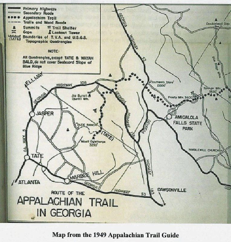
By 1956, numerous reports were being written by members of the Georgia Appalachian Trail Club (GATC) and others about moving the terminus of the trail to Springer Mountain. In 1958, the Appalachian Trail Conference voted to relocate the terminus of the Appalachian Trail. Part of the trail in Dawson County which was on state and federal land remained as the Approach Trail to Springer Mountain which today begins in Amicalola State Park. Those who built the Appalachian Trail in Pickens and Dawson Counties may have considered themselves trail blazers. But, they were not the first to open trails on these mountain ridges. The Cherokees were here before them and they had trails along these ridges as far back as the 1700’s or even earlier. The Cherokees sometimes used bent trees to mark their trails or point out places to find water, shelter and other things. Some of these Marker Trees can still be found today along the pathways leading up to Oglethorpe Mountain and north along the ridgeline toward Ellijay, a major Indian Town. Several of these Marker Trees have been cored in order to age them. The oldest Marker Tree cored to date is 1768! Many others are dated in the late 1700’s and early 1800’s. These trees tell a story of those that went before us along these ridges and trails when this area was truly a wilderness. Two hundred years of man’s impact on theses forested lands have changed the wilderness, not for the better. Some of it still remains but for how long?
READ MORE ABOUT...
The Early Days before Bent Tree – Part 1 > The Old Dude Ranch
The Early Days before Bent Tree – Part 5 > The Appalachian Trail