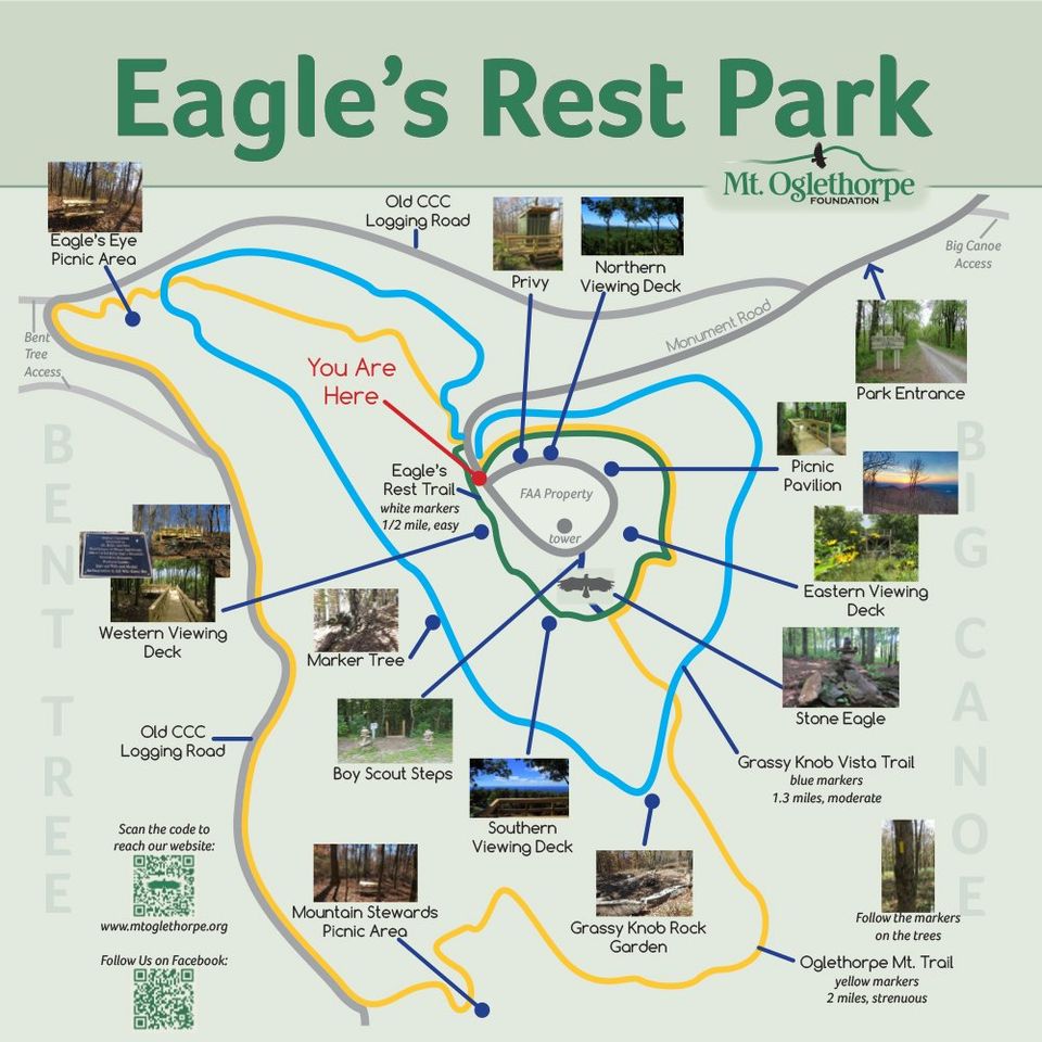
GATE HOURS: 7AM - 8PM


HIKING TRAILS

ACCESS TO TRAILS

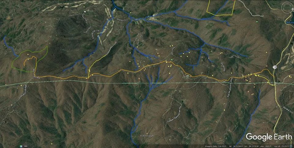
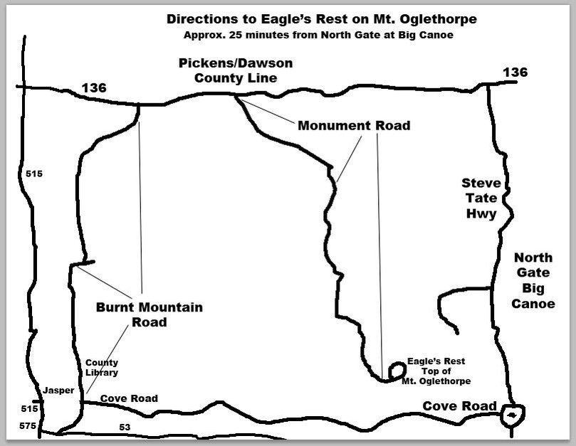
Follow Rt. 136 to Burnt Mt. and turn south on Monument Road. Follow Monument Road to the very end (about 5 miles) and enter the Eagle’s Rest site. Drive up the hill to the parking area with the kiosk on the left. The trails start behind the kiosk.

The Oglethorpe Mt. Trail begins at the same location as the Eagle’s Ridge Trail and follows that trail around the mountain to the east and then south for ¼ mile. On the south side of the mountain, the Oglethorpe Mt. Trail branches off to the south and heads down the mountain ridge before turning back to the west making the 500 foot elevation drop. In ½ mile, the trail will come to a short trail that leads to a picnic table and the triple springs where the hiker can rest.

From the double springs, the trail continues to the west for 0.1 mile to reach the old CCC Road where the trail turns north (to the right) and follows the CCC Road for ½ mile to the next turn. Where the CCC Road makes a 90 degree turn, the trail will also turn back to the east and head up the mountain for a 1/3 mile to the trail starting point. Near the turn from the CCC Road is another picnic table for resting before completing the trail to the top of the mountain.

Hiking boots are recommended for the Oglethorpe Mt. Trail.

Seasonal wildflowers and native azaleas can be seen along the trails.

As you enjoy this special place we, the Board Members of the Mt Oglethorpe Foundation ask you adhere to these simple rules and regulations:

  • ​Leave only footprints and natures gifts for others to enjoy.
  • No firearms
  • No Horses or Four-wheelers on the trails
  • No Fires of any kind
  • No Alcohol
  • Please take your throw-a-​ways home with you

Oglethorpe Mt. Trail:

This trail is approximately 1.8 miles long with a 500 foot elevation change down and back up. The trail is rated moderate to strenuous depending on your hiking skill level and should only be hiked by seasoned hikers accustomed to longer hikes. Follow the yellow blazes.

When you visit the site, if you can, bring a rock to place in the Eagle Sculpture being built on the southern end of the top of the mountain.

Legend:
Distance ~ .5 mi
Difficulty: Easy 

Eagle's Rest Trail:

This trail is relatively level with minor elevation changes. Oglethorpe Mt. trail circles the top of the mountain in a clockwise direction, returning back to the parking area. The trail is ½ mile. Follow the white blazes.

Legend:
Distance ~ .5 mi
Difficulty: Easy                     

 Legend:


White:      Eagle;s Rest Trail
Yellow:    Oglerthorpe Mt Trail
Blue:        Grassy Knob Vista Traill
Green:      Property line

Some History Behind The Trails


December 9, 2016 - From Don

​"Clardy (Schwarz) and I mapped the Indian Trail in Big Canoe today going from the village site and heading westward. The overall map of its location is below for reference.

Some of what we learned using the dowsing rods to ask probing questions and getting answers may confirm some of what you may have suspected about Big Canoe but there are some answers you may not want to hear.

First of all is the information about the Indian village site. In 2003, I brought a Cherokee elder into Big Canoe to bless the large Marker Tree on Wildness Parkway. Before the ceremony, I drove him around Big Canoe and he told me then that he suspected the Indian village would be located in Pettit Lake near the island. So Clardy and I started on the lake side of the dam and started asking question whether there was an Indian village located nearby. I started out asking if there was a Cherokee village and got a no answer. I then asked if there was an Indian village and got a yes answer. Since it was not answering to Cherokee, I asked if it was a Creek Indian vilalge and got a yes. I then asked the rods to point to the village location and they rotated and pointed to the SE end of the Pettit Lake Island which would be where the stream flowed before the lake was filled. This information leaves us with a quandry. There is written accounts of Cherokee's living in the Big Canoe area so is there another village site we did not find or did the Cherokee move into the Creek village site after they left around 1750. Most of the graves that have been found on the mountain trail and Eagle's Rest Park are Cherokee so they were in Big Canoe but we are not getting good answers as to their village location other than they most likely occupied the Creek site. At some point, we need to get on the Pettit Lake Island and explore it.

From the village site, we collected waypoints across the dam where we found the trail using the rods and later collected waypoints at the bottom of the dam and across the park. From that location the trail wanders in a westerly direction to intersect with the Jeep Trail which is the Indian Trail. We did not fully check the trail from the dam to the Jeep Trail due to houses being in the way but the terrain was used to lay down the trail to the intersection point. The picture attached labeled Big Canoe Marker Tree sits at the intersection of the trail coming from the village to where it joins the Jeep Trail. From that point west to the entrance of the Nancy Womack Trail off of the Jeep Trail, the Indian Trail was found to follow the Jeep Trail exactly. We checked several location along the Nancy Womack Trail and all indicated this was the Indian Trail. Since the Nancy Womack follows Disaroon Creek, I used that terrain feature to lay down the trail going uphill. I had previously mapped the trail coming down from Eagle's Rest Park and that trail was heading right to Nancy Womack so I connected them. At some point, we shoud get a group together and hike down Nancy Womack to locate the exact trail junction point and have a car at the Valley View junction to pick us up.

One other feature discovered on the trail is a Marker Tree right at the junction where the Nancy Womack starts off of the Jeep Trail. It is labeled Big Canoe Marker Tree-grave. This tree dowsed for water so it is an authentic Marker tree. Since it points directly to Disaroon Creek and its so close, its hard to believe this would be a water marker tree. So I asked if it pointed to a grave and got a yes answer. I located the grave near the creek and determined the grave was a Cherokee woman. On further probing, I learned she died from a disease and died during the Trail of Tears. Learning this, I went back and stood on the Indian Trail and asked if this trail was used in the Trail of Tears and got a yes respond. Of not, a number of the Cherokee graves along the ridge trail also died during the Trail of Tears.

So there you have it; some good and some leaving us scratching our heads. Now that we know the location of the village, I suspect there is also another Indian trail going from the village site to the Rock Cairn site. This needs to be explored when time permits."

December 10, 2016 - From Don

Prelude -
In development of the property related to Mt Oglethorpe many different skills are required and new skills are learn. It is wonderful opportunity to learn history, nature, ecology, as well as how to design, build, and maintain trails. In ceateing an environment which will be entertaining, education and appeal to the general public a deidcated group of volunteers has formed to build and maintain trails, strucktures for viewing. T limited toilet facilities. Mountain Stewards, who have been instrumental in the development of Mt Oglethorpe park. Don Wells is President of the Mountaion Stewards as well as an Indian historian. Don has conceived and lead several efforts which has greater expanded the knowledge of the area and its inhabitants and ecology.  

Because of Don's intimate involvement in this undertaking it is appropriate to use his first person narative of his reporting.
So Don's reporting of his "exploing for Indian Trails on around Mt Oglethorpe​" follows.          
Don in his own words:

"I have been experimenting with new dowsing techniques and have learned how to locate and track Indian trails. This technique is similar to how I can track underground water. Once I'm in the vicinity of the trail, I can use the rods to point out the direction of where the trail is located and then head in that direction with the rods held out in front of me until they cross which is the trail location. I usually at this point use the rods to confirm the trail location by asking if this is the Indian trail and getting the rods to cross in front of me giving a yes response. Once I locate the trail I turn 90 degrees and begin to follow the trail keeping the rods crossed. If I drift off of the trail, the rods will open and I know to go left or right to find it again. By walking the trail and collecting waypoints, I can plot the trail location fairly precisely. The trails are plotted on Google Earth and an image of their location is attached. The map is oriented with north to the right side and south to the left so you can see the entire trail. This represents a five mile segment of the ancient Indian Trail. Along the trail on the ridge I have found a number of graves sites which have been determined to be Cherokee. Some of those found on the side trails have been determined to be Creek.

The main trail is plotted in orange and goes from Oglethorpe Mt to Rt. 136 and beyond but not tracked yet. This trail starts in Big Canoe and has to be mapped there soon. Branching off of this main trail are several other trails. One trail goes west to Sharp Top Mt., a sacred place to the Indians and will have to be mapped soon through Bent Tree. A second trail I believe is heading toward Amicalola Falls which was a sacred place so I expect the yellow trail near the end of Monument Road is heading there.

A decade ago, we plotted a number of Marker Trees on the suspected Indian route but could not prove it. Some of the Marker Trees I passed right by as I mapped are attached. Thus these trees are marking the Indian trail. Some are pointers and some of water markers that mark the location of springs. These are sometimes called snout trees as they have a long snout pointing down at 45 degrees. When you see one of these, there is usually a spring within a hundred yards of the tree."

Share by: